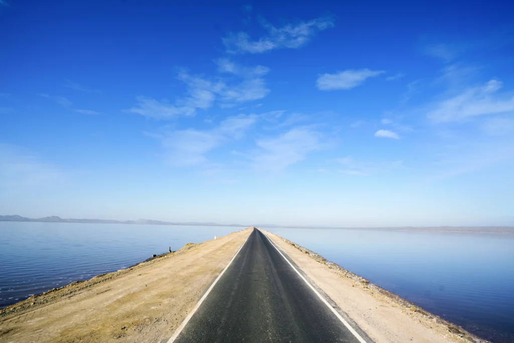
Imagine a road that goes nowhere and everywhere at the same time. A perfectly straight strip of tarmac, 30 kilometres long, running through the Great Rann of Kutch white salt desert on both sides, blue sky above, the horizon somewhere beyond the visible edge of the world. On either side of this road, the ground and the sky are the same colour. There are no trees, no buildings, no curves, no other references. There is only the road, going forward, and the sense that you are not driving across a desert but through the sky.
This is the Road to Heaven and the name is the most accurate piece of geographical description in Gujarat. A 30-km highway connecting Khavda village to Khadir island (where the Dholavira UNESCO World Heritage Site is located), built in 2019 and improved ahead of the 2023 G20 Summit, the Road to Heaven has become one of the most viral, most shared, most photographed drives in India in the space of just a few years. Drone shots of it look like a floating ribbon woven between two mirror-surfaces. Ground-level photographs look like the vanishing point of the universe. Bikers cross it in minutes and spend hours trying to describe what it felt like.
This TravelRoach guide covers everything about the Road to Heaven as a standalone experience: where it actually is, when to go for the best conditions, what the drive looks and feels like at different times of day and season, the photography tips, how to combine it with the Rann Utsav and the Kutch circuit, and how to reach it from Bhuj and Ahmedabad. The Road to Heaven is free. It is extraordinary. And it will make you stop the car and get out.
Road to Heaven Kutch — Quick Information
| Detail | Information |
| Location | Kutch District, Gujarat — the Aadhav-Dholavira Road, connecting Khavda to Khadir island |
| Length | ~30 km (the full Khavda-Khadir stretch; the ‘Road to Heaven’ experience begins at Adhav village, ~22 km from Khavda) |
| The Route | Khavda → Adhav village → across the Great Rann salt flats → Khadir island → Dholavira |
| Built | 2019 (the highway); cleared as 31.9 km Khavda-Khadir road ahead of G20 Summit 2023 |
| Why It’s Called Road to Heaven | Perfectly straight road through white salt desert; sky and ground appear to merge; illusion of driving into infinity |
| The Physics of the Experience | Salt flats reflect the sky; shallow seasonal water creates mirror effect; no vertical objects to break the horizon |
| Entry Fee | Free — no toll, no ticket, open public highway |
| Best Time of Day | Sunrise (most dramatic) and sunset (golden hour on the white salt — extraordinary colour) |
| Best Season | November to February — salt flats firm and white; shallow reflective water still present post-monsoon |
| Avoid | Summer (April-June, 45°C+); peak monsoon (July-August, road may flood) |
| Post-Monsoon Special | October-November: shallow water still on the salt flats produces the most mirror-like reflection effect |
| Distance from Bhuj | ~90–100 km to the start of the Road to Heaven (Adhav village), ~2-2.5 hours |
| Distance from Dhordo (Rann Utsav) | ~40–50 km from Dhordo via Khavda |
| Distance from Kalo Dungar | ~50 km from Kalo Dungar via Khavda |
| Distance from Dholavira | ~30 km (Road to Heaven ends at Khadir island where Dholavira is) |
| Road Surface | Well-paved highway; no off-road sections required |
| Good For | Photography, road trips, motorcycles, self-drives, sunrise/sunset watching |
| Facilities On The Road | None — completely bare desert stretch; carry fuel, water, and food before entering |
| Nearest Fuel | Khavda village (before starting); confirm fuel availability before the salt flat section |
| Nearest Food | Dholavira village (end point) or Khavda (start point); nothing on the road itself |
| Stargazing | Exceptional — minimal light pollution across the entire stretch; dark sky photography possible |
What Is the Road to Heaven – The Complete Story
The Road’s Origin
The Road to Heaven is not ancient. It is not a route that has been walked for centuries or a pilgrim path with sacred history. The Khavda-to-Khadir highway was built in 2019, primarily to improve connectivity to the Dholavira archaeological site which was being developed for UNESCO World Heritage nomination (inscribed in 2021) and needed better road access to support tourism infrastructure. The road was further improved in 2022-2023 ahead of India’s G20 Summit, during which Dholavira was selected as one of the showcase heritage sites.
What happened next was entirely unplanned. Travellers, photographers, and video creators who drove the new road discovered something that no infrastructure brief had accounted for: the 30-kilometre stretch across the Great Rann produced a visual experience unlike anything else available in India. The first drone videos circulated. The photography started appearing on social media. A YouTube vlogger published a video called ‘The Road That Touches Heaven’ documenting the journey from Bhuj to Dholavira, with the Rann crossing at its centre and the name became the name.
The Government of India’s branding of the route as ‘Road to Heaven’ formalised what travellers had already been calling it. Today it appears on Gujarat Tourism materials, on Google Maps entries, and in the vocabulary of every travel agent and tour operator working the Kutch circuit.
Also Read : Aina Mahal Bhuj Kutch
The Physics of the Experience – Why It Looks Like Heaven
The visual experience of the Road to Heaven is the product of specific physical conditions that the Great Rann of Kutch creates at certain times of year. Understanding these conditions helps you plan to see the road at its most dramatic.
The Great Rann is a seasonal salt marsh. In the monsoon, the entire surface floods. As the monsoon ends (September-October) and the floodwater gradually evaporates, a shallow layer of water remains on the salt flats thin enough to walk through but deep enough to perfectly reflect the sky above. For a period of several weeks in October and November, this shallow water creates a mirror surface that extends in every direction from the road.
When this reflection is active, the road appears to float on water a causeway between two sky-surfaces. Above, the sky. Below, the sky’s reflection in the shallow water. In between, the road. The horizon in every direction blends sky and reflection so seamlessly that your visual system cannot identify where the ground ends and the air begins. The road goes into this convergence point into the apparent horizon of everything.
As the dry season progresses (November to February), the water evaporates fully and the salt flat becomes dry brilliant white, flat as a table, extending to every edge of the visible world. The mirror effect is less intense, but the white-on-blue visual of salt desert meeting clear winter sky is equally dramatic. The light on a January morning on the Road to Heaven, when the sun is at a low winter angle and everything is white and clear, is the kind of light that makes every photograph look like it was taken on a different planet.
The Social Media Story – How a New Road Became a Legend
The Road to Heaven’s viral quality is a product of drone photography in a way that almost no other Indian destination is. The overhead shot of this road from a drone at 50 to 100 metres altitude produces an image that human eyes cannot see from ground level but that instantly communicates the road’s extraordinary visual character: a thin black line, perfectly straight, floating in the centre of a frame that is otherwise entirely white (salt) or entirely blue (sky and its reflection), with no buildings, no curves, no traffic, no indication that this is a road on earth rather than a line drawn across the universe.
This image type clean, graphic, otherworldly, immediately understandable is exactly what travel content optimised for Instagram and YouTube responds to. The drone shots of the Road to Heaven travel further and faster than drone shots of almost any comparable Indian destination. The road has its own aesthetic language, and that language is entirely visual: you do not need to explain what you are looking at. You see the image and you want to be there.
The Experience – What Happens When You Drive It
The Approach – Banni Grasslands and Artisan Villages
The Road to Heaven proper begins at Adhav village, approximately 22 kilometres from Khavda. But the journey from Bhuj to this point passes through one of Kutch’s most distinctive cultural landscapes: the Banni Grasslands. The Banni is a semi-arid grassland belt between Bhuj and the Great Rann, home to the Maldhari pastoral communities (including Rabari and Jat groups) whose intricately embroidered textiles are among the most recognised craft traditions in India. The villages along the Bhuj-Khavda road Hodka, Ludiya, Nirona, and others are active craft centres where copper bells, leather goods, rogan painting, and embroidery are made.
Khavda village itself is the last significant settlement before the Road to Heaven. Refuel here (the last fuel stop before Dholavira). The village also has basic tea and food options. From Khavda, the road continues toward Adhav, and the landscape begins its transformation: the Banni scrub gives way to salt flat margins, the visual horizon opens, and the first glimpse of what is ahead appears.
Adhav to Khadir – The 30 km Experience
The genuine Road to Heaven section begins at Adhav village, where the road transitions from the Banni margin onto the causeway approach to Khadir island. For the next 30 kilometres, until the road climbs slightly onto the Khadir island landmass and reaches the Dholavira village, there is salt flat in every direction.
The correct way to experience this road is not to drive through it but to stop in it. Pull over at multiple points. Get out of the vehicle. Stand on the road (safely be aware of other traffic, which is sparse but present). The experience standing on the Road to Heaven is fundamentally different from the experience inside a moving vehicle. Inside the vehicle, the landscape moves past you. Standing on the road, the landscape is completely still, completely silent except for the wind, and completely surrounding. You are in the white desert. There is no destination visible in any direction. The road goes into the sky ahead and the road goes into the sky behind. You are, for as long as you choose to stand there, nowhere in particular and somewhere completely specific.
The Light – Why Timing Changes Everything
The Road to Heaven at noon is flat and slightly bleached the overhead sun creating minimal shadow, the white salt absorbing and reflecting simultaneously in a way that is more visually taxing than beautiful. This is the version of the road that many visitors who don’t plan carefully experience, and it explains why some people are underwhelmed.
The Road to Heaven at golden hour the 45 minutes before and after sunrise, or the 45 minutes before and after sunset is a completely different phenomenon. The low sun angle strikes the salt surface at the same angle it strikes a calm ocean surface, creating specular reflection rather than diffuse scatter. The salt flat turns gold, then orange, then pink, then purple in sequence as the sun descends. The road, surrounded by this colour progression, takes on colours that seem impossible in a desert.
The Road to Heaven in the pre-dawn dark, with a clear winter sky, is a third experience: the Milky Way visible from horizon to horizon, the darkness absolute in every direction except upward, and the road visible only as the absence of stars where the tarmac blocks the ground. This is why the Road to Heaven appears in dark sky photography guides alongside sites in Rajasthan and Himachal Pradesh that have historically monopolised India’s night sky photography.
The Road to Heaven as Part of the Full Kutch Circuit
No visit to the Road to Heaven should happen in isolation. The road is the connecting thread of one of Gujarat’s richest multi-day road trip circuits a loop out of Bhuj that covers the full Kutch experience. Here is the classic 2-to-3-day circuit:
Day 1: Bhuj to Dhordo (White Rann and Rann Utsav)
Leave Bhuj early morning. Drive north toward Dhordo via Bhirandiara and Anjar. En route, detour to the Kala Dungar (Black Hill) the highest point in Kutch at 462 metres, where a Dattatraya temple sits at the summit, and where priests have fed foxes at sunset every evening for years, the foxes arriving with remarkable punctuality as the light fades. From Kalo Dungar, the White Rann is visible stretching north to the horizon. Reach Dhordo and, if it is the Rann Utsav season (October to March), enter the tent city for the night. The White Rann at full moon, seen from Dhordo, is the defining Kutch experience.
Day 2: Dhordo to Road to Heaven to Dholavira
The morning drive from Dhordo toward Khavda brings you through the landscape that transitions from White Rann to the Road to Heaven approach. From Khavda, the Road to Heaven begins at Adhav allow yourself unhurried time on this stretch. Stop as many times as you like. Photograph the road in the morning light. Stand on it. Drive it slowly. At the far end of the 30-kilometre crossing, the land rises slightly onto Khadir island and Dholavira appears. Spend the afternoon and evening at the Dholavira archaeological site (5,000-year-old Harappan city, UNESCO World Heritage). Sunset from Chipper Point on Khadir island, with the Road to Heaven visible below stretching back toward the mainland the day’s journey visible from its endpoint.
Day 3: Dholavira Return to Bhuj
Drive back across the Road to Heaven in the morning experiencing it a second time in the opposite direction, different light, possibly different atmospheric conditions. Return to Bhuj via Bhachau, stopping at handicraft villages along the way. The Kutch Museum in Bhuj, and the Aina Mahal, complete the circuit’s heritage dimension.
Also Read : Narayan Sarovar Lakhpat Kutch
Kalo Dungar – The Viewpoint That Shows You Where You’re Going
The Kalo Dungar (Black Hill), at 462 metres the highest point in Kutch, is an essential pre-Road to Heaven stop not because it is on the same road but because it shows you the Great Rann from above before you drive through it. From the Dattatraya temple at the summit (approximately 97 km from Bhuj), the White Rann stretches north in every direction: white, flat, enormous, and extending to what appears to be the horizon of the entire planet.
The sunset here is one of Kutch’s finest natural spectacles. As the sun descends toward the Pakistan border (visible on clear days), the light on the salt flats below undergoes the same golden-to-pink-to-purple colour sequence that the Road to Heaven experiences from ground level but viewed from above, so that you can see the full scale of the landscape. And then, at sunset, the foxes arrive at the temple to be fed. Every evening, without fail, wild desert foxes gather at the Kalo Dungar temple for the food offered by the priests a tradition whose origin is lost in time but whose regularity is remarkable. The foxes are not domesticated. They come because they have learned that they are welcome.
Photography Guide – How to Shoot the Road to Heaven
For Drone Photography
The Road to Heaven is one of India’s finest drone photography subjects. The bird’s-eye view of the straight road flanked by salt flat produces an instantly recognisable image type: the floating ribbon. Optimal altitude is 50 to 100 metres enough to see the road’s full context without losing the detail of the reflection or the surface texture. The best window for drone photography is 30 minutes after sunrise and 30 minutes before sunset, when the light angle produces the strongest shadow contrast and the richest colour in the salt surface. Post-monsoon October-November, when shallow water creates mirror reflection on both sides of the road, is the most dramatic season for drone shots of the full reflection effect.
For Ground-Level Photography
At ground level, the Road to Heaven’s visual character depends almost entirely on the light angle. The best ground-level shots are: standing in the middle of the road (ensure safety) and shooting directly toward the vanishing point, with the road running into the apparent convergence of sky and ground; stopping at a point where the reflection is active and shooting from low angle (crouch or lie on the road) to maximise the reflection in the foreground; and shooting silhouettes a vehicle, a person, a bicycle at the golden hour when the sky is lit and the road is in relative shadow.
For Night Photography
The Road to Heaven is a genuine dark sky photography site. The absence of any light pollution across the entire 30-kilometre stretch, and the absence of trees or structures that block the horizon, means the night sky is visible from horizon to horizon in every direction. The Milky Way, when the moon is absent (two weeks per month), is visible as a dense band running across the full overhead dome. Set up a wide-angle lens at the road’s edge with the road running into the frame; a 20-to-30 second exposure will capture both the Milky Way above and, if there is reflective water below, its mirror image beneath.
Best Time to Visit the Road to Heaven
| Season / Period | Conditions | What to Expect |
| October–November | Post-monsoon; shallow water on salt flats; warm days | BEST for mirror reflection; road floats on sky and water simultaneously; drone shots at peak |
| December–February | Winter; salt flats dry and white; cool to cold | Best overall comfort; brilliant white salt; golden hour colour; stargazing at peak; Rann Utsav running |
| March | Late winter/early spring; warming | Still good; white salt beginning to dull; comfortable daytime |
| April–June (Summer) | Extreme heat; 42–45°C+ | AVOID — the visual experience remains but the physical experience is dangerous in extreme heat |
| July–August (Monsoon) | Road may flood or become unsafe | AVOID — the Rann floods; access to Khadir island may be cut |
| September | Post-monsoon transition; road re-opening | Check conditions locally; water may be arriving on the flats; early for the full reflection effect |
How to Reach the Road to Heaven
| From | Distance | Mode | Approx. Time |
| Bhuj to Adhav village (start) | ~90–100 km via NH27 and Khavda | Car / Motorcycle | 2–2.5 hours |
| Bhuj to Khavda (last town) | ~70–80 km | Car / Motorcycle | 1.5–2 hours |
| Dhordo (Rann Utsav) to Road to Heaven via Khavda | ~40–50 km | Car | 1–1.5 hours |
| Kalo Dungar to Khavda | ~50 km | Car | 1 hour |
| Dholavira (end of road) to Bhuj return | ~165 km via Bhachau | Car | 3–3.5 hours |
| Ahmedabad to Road to Heaven (via Bhuj) | ~400 km | Car (+ overnight at Bhuj) | 6.5 hours to Bhuj then 2 more |
| Bhuj Airport to Road to Heaven | ~90–100 km | Taxi | 2–2.5 hours |
The only way to reach the Road to Heaven is by private vehicle own car, hired taxi from Bhuj, or motorcycle. There is no public bus service directly on this route. Navigate to ‘Adhav Village, Kutch’ or ‘Dholavira, Kutch’ on Google Maps to follow the Khavda-Dholavira route. From Bhuj, take NH27 north toward Dhordo, then branch toward Khavda. Ensure your tank is full at Khavda; there is no fuel station on the 30-kilometre salt flat section.
What to Combine With the Road to Heaven
- Dholavira – UNESCO World Heritage Harappan City – At the end of the Road to Heaven (Khadir island) | The 5,000-year-old Indus Valley Civilisation city; India’s 40th UNESCO World Heritage Site; Chipper Point viewpoint with panoramic Rann views. Read our full TravelRoach guide.
- Rann Utsav, Dhordo – ~40–50 km via Khavda | The world-famous White Rann cultural festival, running October to March: tent city under the stars, folk performances, Kutchi handicraft markets, White Rann at full moon. The Road to Heaven connects the Rann Utsav site directly to Dholavira.
- Kalo Dungar (Black Hill) – ~50 km from Khavda | The highest point in Kutch (462m) with views over the White Rann and the India-Pakistan border; the sunset fox-feeding tradition at the Dattatraya temple; a pre-Road to Heaven altitude perspective on the landscape you are about to cross.
- Khavda Village – ~70-80 km from Bhuj, the last village before the salt flat | Kutchi handicraft village; Khavda is known for its traditional embroidery, rogan art, and copper bell-making workshops. Worth 30-45 minutes before beginning the Road to Heaven drive.
- Aina Mahal and Bhuj Heritage – Bhuj city (~90-100 km from Road to Heaven) | The Palace of Mirrors; the Bhuj 2001 earthquake memorial; the Kutch Museum. Read our full TravelRoach guide.
Also Read : Wild Ass Sanctuary Little Rann
Practical Tips for the Road to Heaven
- Fill fuel at Khavda – there is no fuel station on the 30-kilometre salt flat section. Do not attempt the crossing on a reserve tank.
- Carry water for at least 4 hours – even in winter, the salt flat environment dehydrates quickly. Carry minimum 2 litres per person; more in spring.
- Start at dawn or 1-2 hours before sunset – the golden hour light makes the Road to Heaven; midday makes it ordinary. The 45 minutes before sunrise or the 45 minutes before sunset are the windows to plan your entry onto the salt flat section.
- Stop the car and get out – this is not a road to drive through; it is a road to stop on. Multiple stops, each one 10-15 minutes, are better than a single 30-minute crossing at speed.
- Fly a drone responsibly – the Road to Heaven is one of India’s finest drone photography subjects; be aware of airspace restrictions in the border zone and ensure your drone is DGCA-registered and operated in compliance with current regulations. The India-Pakistan border is nearby.
- Stargazing is exceptional – if spending the night near Dholavira, bring a telescope or at minimum binoculars; the Road to Heaven’s complete absence of light pollution makes this one of India’s finest dark sky sites.
- Salt flat walking – during the dry season, the salt flat adjacent to the road is walkable; explore carefully, wear enclosed shoes (the salt crust can hide soft mud below the surface), and do not venture far from the road.
- Motorcycle riders – the Road to Heaven is a bucket-list motorcycle route; the straight, smooth, traffic-minimal road and the surreal landscape make for one of India’s finest solo or group motorcycle experiences. Pack a rain layer for sudden weather changes.
Frequently Asked Questions (FAQs)
The Road to Heaven is a 30-km highway in Kutch District, Gujarat, running from Khavda village to Khadir island (where the Dholavira UNESCO World Heritage Site is located), crossing the Great Rann of Kutch salt desert. The road is famous for the visual illusion it produces: with white salt flats on both sides, the horizon blends sky and ground so seamlessly that the road appears to float in mid-air and travel directly toward infinity. Post-monsoon, when shallow water creates mirror reflection on the salt surface, the effect is even more dramatic. The road was built in 2019 and became widely known after the 2023 G20 Summit; it is free to use, open to all vehicles, and one of India’s most photographed drives.
The Road to Heaven is on the Aadhav-Dholavira Road, connecting Khavda village to Khadir island in the Great Rann of Kutch. The significant visual experience begins at Adhav village, approximately 22 km from Khavda, and continues for 30 km until the road reaches the Khadir island landmass where Dholavira is located. The road is approximately 90 to 100 km north of Bhuj about 2 to 2.5 hours by car or motorcycle on NH27 via Khavda. Navigate to ‘Adhav Village, Kutch’ or ‘Aadhav-Dholavira Road’ on Google Maps to find the starting point.
October to February is the best overall visiting period. October and November are specifically the most visually spectacular months shallow post-monsoon water still covers the salt flats, creating the mirror reflection effect that makes the road appear to float between two sky-surfaces. December to February offers the brilliant white dry salt flat, clear winter skies, and comfortable temperatures for extended photography and walking. Summer (April to June) should be strictly avoided 45°C+ temperatures make the exposed salt flat crossing dangerous. The monsoon (July to August) may flood the road. Within any day, dawn and sunset produce dramatically better conditions than midday.
No – the Road to Heaven is a public highway and there is no entry fee, ticket, or toll to drive it. It is free to use for all vehicles. There is also no gate or formal entry point you simply drive into the salt flat section as you travel from Khavda toward Dholavira. The only costs associated with the Road to Heaven are your vehicle’s fuel (ensure a full tank at Khavda there are no fuel stations on the 30-km salt flat crossing) and any accommodation you choose near Dholavira or at the Rann Utsav tent city near Dhordo.
Yes – and this combination is one of Gujarat’s most rewarding single-trip experiences. The Rann Utsav is held from October to March at Dhordo, approximately 40 to 50 km from the Road to Heaven’s start point at Khavda. The classic circuit: Bhuj → Kalo Dungar (Black Hill, sunset and foxes) → Dhordo (White Rann, Rann Utsav tent city, overnight) → Khavda → Road to Heaven → Dholavira (Harappan city, Chipper Point sunset) → return to Bhuj. This 2-3 day loop covers the Road to Heaven, the White Rann, Rann Utsav’s cultural programme, the world’s most visually dramatic Harappan site, and one of Kutch’s finest viewpoints.
A full fuel tank (fill at Khavda no fuel on the 30-km crossing); minimum 2 litres of water per person; food and snacks (no shops or restaurants on the road); a working GPS or Google Maps download of the area (mobile signal may be weak in the middle of the salt flat); a power bank for phone and camera; a drone if you have one and the required permits; warm layers for winter evenings and early mornings (December-January temperatures drop quickly after sunset); a camera and tripod for long-exposure photography; and sturdy shoes if you plan to walk on the salt flat surface adjacent to the road.
Final Thoughts
India has road trips and India has drives. The Road to Heaven is neither of these things. It is a 30-kilometre period of disorientation a temporary suspension of the usual cues that tell you where the earth ends and the sky begins, where you are heading, and whether what you are driving on is a road or a flight path.
No road in Gujarat is as simple as this one. No road in India produces as immediate a visual argument for stopping the car, getting out, and standing quietly in the middle of a landscape that has temporarily run out of the usual components of landscape. There are no mountains. There are no trees. There is no town visible. There is no destination until you arrive at one. There is the road, the salt, the sky, and the light changing all three every 15 minutes as the sun moves.
It was built in 2019. It became world-famous in 2023. It will be there tomorrow morning when the sun comes up and turns the salt flat into gold.
Drive it at sunrise. Stop the car. Get out. Look in every direction. Take the photograph. Then keep driving because Dholavira is at the end of this road, and 5,000 years of human civilisation are waiting, just past the point where the sky meets the ground.
Have you driven the Road to Heaven? Share your experience the time of day, the light, what it felt like to stop the car and stand in the salt flat in the comments. TravelRoach would love to hear from every Kutch road tripper.
